Backstage Pass to North Dakota History

This blog takes you behind the scenes of the State Historical Society of North Dakota. Get a glimpse at a day-in-the-life of the staff, volunteers, and partners who make it all possible. Discover what it takes to preserve North Dakota's natural and cultural history.

A Matter of Interpretation: Bringing History to Life at State Historic Sites

Learning how to tell stories objectively isn’t always easy. Not many people realize it, but the Lewis & Clark Interpretive Center and Fort Mandan State Historic Site where I work is staffed with team members who are nationally certified in interpretation. To obtain certification, our staff attends training courses offered through the National Association for Interpretation (NAI). These are weeklong programs, which teach the core principles of interpretation.

One might ask, “What is interpretation?” NAI defines it as “a purposeful approach to communication that facilitates meaningful, relevant, and inclusive experiences that deepen understanding, broaden perspectives, and inspire engagement with the world around us.”

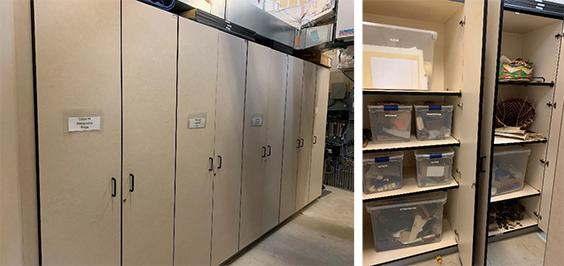
So how does that apply to these sites? Through our training from NAI, we are able to help visitors better understand and relate to site content, and hopefully spark interest in furthering their knowledge of what they learn at these sites. We do so by offering hands-on items that bring seemingly intangible information learned through textbooks or novels to life. The Lewis & Clark Interpretive Center and Fort Mandan State Historic Site hold more than 1,500 items (mainly replicas) related to their content. Using replicas allows us to offer visitors the opportunity to handle some of these items. In a sense, we are able to put history into the hands of visitors. Interpretive Resource Specialist Shannon Kelly makes sure all the items we acquire are both historically accurate and add to the story the sites tell. A recent commission by the agency included a beaded belt by Hunkpapha Lakhota/Hidatsa artist D. Joyce Kitson. The purpose of the belt is to allow visitors to handle and contextualize what this representative piece of history may have been like.

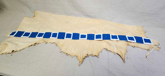
This blue beaded belt by Hunkpapha Lakhota/Hidatsa artist D. Joyce Kitson will be used as an interpretive piece for staff to discuss Sacagawea’s possessions and attire during the expedition. We do not know the exact design of Sacagawea’s belt, but this is a good approximation.

Aside from historical items at the site, we also have a lot of programming. From arts and crafts to geology and navigation, we add fun educational activities for visitors. Certified Interpretive Guide (CIG) training teaches you how to develop these programs. Staff then create engaging interactive activities and programs that allow visitors to get the most out of their visit. One recent program we ran was a paper boat challenge, where visitors were taught how to make paper boats and then offered “provisions” in the form of beads, corn, corks, and wooden clothespins. The visitor was tasked with loading up their boat with the provisions and seeing how long it could stay afloat while dealing with the elements (or in this case, people splashing).

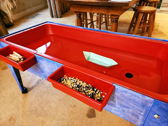
Our setup for a recent paper boat challenge held at the Fort Mandan State Historic Site Visitor Center near Washburn.

Once staff obtain their certification, they are required to maintain credits for their NAI membership, and this is done by attending its conferences. After an NAI conference, staff come back motivated, inspired, and sometimes even with a new skill set. In November 2023, Bethany Schatz, one of our team members, and I went to Little Rock, Arkansas, for the NAI National Conference. While there, we attended a workshop on 19th-century blacksmithing. Bethany was offered the opportunity to make an item in the forge. She created a steak flipper, which is something that could have very easily been made by the blacksmiths of the Lewis and Clark Expedition. From the forge to the tools, it was all similar to what would have been used in 1804 at the site. Bethany was able to experience in just a short amount of time what it would have been like to work as a blacksmith during the expedition. Not only did she leave the session with a new item she created with her own hands, but she also left with a desire to learn more about the trade as well as how to bring similar hands-on learning experiences to the site and spread inspiration to visitors.

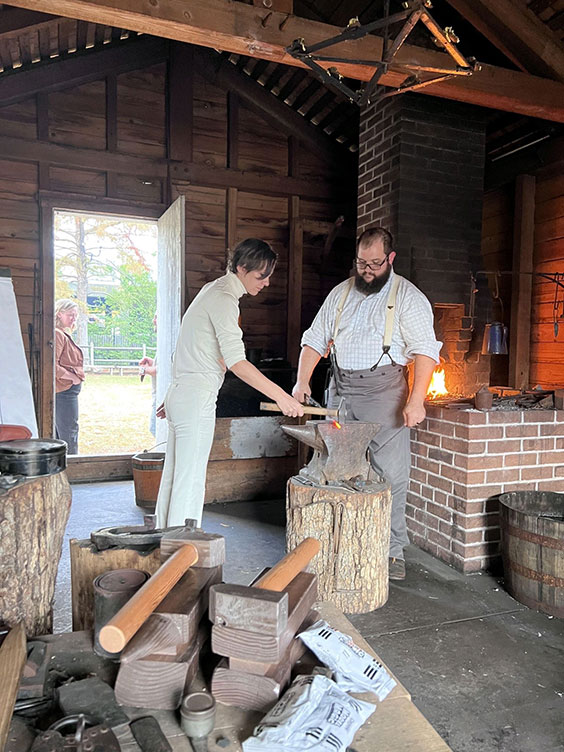
Seasonal employee Bethany Schatz learns how to blacksmith during the 2023 NAI National Conference in Little Rock, Arkansas. Bethany was guided through the steps to make a steak flipper by Historic Arkansas Museum site interpreter/residential blacksmith Casey Marshall.

In North Dakota, we are fortunate to have nationally certified interpreters at many of our state historic sites and museums. After all, interpretation is a way to connect with visitors, help develop their interests, and cultivate memorable experiences. Come check us out!

The Lewis & Clark Interpretive Center: So Many Reasons To Go

Here at the Lewis & Clark Interpretive Center we have period artifacts, world-class art, and interpreters who bring to life the story of Lewis and Clark’s expedition west. On a nearly daily basis, someone rushes through the doors of the Interpretive Center, looking as though they are eager to learn about the valuable history on offer, only to make it a few steps inside and suddenly appear confused. That confusion is usually met by a bright-eyed interpreter (currently me) eager to share knowledge with a member of the public. One hundred percent of the time I get to share knowledge with the person, but it’s often more along the lines of directing them to the restroom.

This road sign found along U.S. Route 83 highlights the important “facilities” at the Lewis & Clark Interpretive Center.

Why the rush on our restrooms? The Lewis & Clark Interpretive Center is a designated U.S. Route 83 Rest Area in Washburn with bathrooms available 24/7. We provide a great halfway stopping point between Bismarck and Minot. As a rest area, our site provides excellent amenities. There’s ample truck and car parking, a picnic area, a pet area, water fountains, and Wi-Fi. Even inside the restrooms, we’ve provided clever facts about the Lewis and Clark Expedition for a captive audience! Here are just a few examples of the fun tidbits that adorn the bathroom walls and stall doors:

Monitoring the entrance of the Interpretive Center is a big part of our day-to-day operations. While at the front desk, we are able to accomplish a fair amount of research as well as finish other site work, but we are also called away to help visitors. Even if they don’t explicitly ask which doors lead to the promised land of relief, visitors often have a look of “help me” in their eyes. Sometimes you will encounter a person wandering through the galleries and clearly in need of assistance. Usually that means one of us wasn’t available to redirect the visitor upon entry. Legend has it that the doors to the restrooms only appear after asking an interpreter. I can’t speak for everyone on staff, but for me there’s a sense of understanding and acceptance when you lock eyes with the rest stop visitors. After all, everyone needs a little help navigating the Bermuda Triangles of this world.

This is the Lewis & Clark Interpretive Center’s Bermuda Triangle, where visitors have been known to lose their sense of direction and in some cases make life-altering choices!

The magic door that only appears after asking an interpreter where to find the bathrooms.

I think it’s safe to say most of us working at the Lewis & Clark Interpretive Center are proud of the national attention our site receives; we are grateful for the opportunity to share this bit of North Dakota history with the public. That the site plays a pivotal role not only in our nation’s history but also our state’s history is a pretty a big deal. So if you’re ever on U.S. Route 83, keep an eye out for our road signs and new billboard. There’s so much to see and do here. But we also totally understand if you just need a safe place “to go.”

Our new billboard on U.S. Route 83 invites you to experience all the Lewis & Clark Interpretive Center in Washburn has to offer. Don’t forget we have galleries, too!

From Idea to Interpretive Program: Creating My Mobile Mapping Program

Here at the Lewis & Clark Interpretive Center and Fort Mandan State Historic Site, we host a lot of schools annually. Aside from guided tours of the Interpretive Center and the fort, we create and present educational programs to allow students hands-on learning about some of our site’s topics. Back in 2019, I became a certified interpretive guide through the National Association for Interpretation. To gain my certification I had to create and present a program for our site. I am going to walk you through how I turned my initial idea into a program on mobile mapping.

Step 1: Where do I begin?

The library at the Lewis & Clark Interpretive Center was a great place to find inspiration for my program.

There are a lot of topics we cover at the Interpretive Center such as the fur trade, agriculture, early Western artists, tribes of the Missouri River, and of course the Lewis and Clark Expedition. I did my best to sift through these to find a topic that struck a chord with me. One of the resources we have in our library is a book titled Atlas of the Lewis and Clark Expedition, which contains copies of the maps of the expedition. I found it wildly interesting that the maps were as detailed as they were, even though the cartographers didn’t always have the necessary time to survey or measure things.

This is when I learned about the art of dead reckoning. When the members of the expedition set off, they only had access to maps of the Missouri River beginning in St. Louis, but these maps all essentially end just west of the confluence of the Missouri and Yellowstone rivers. The captains were tasked with improving on their current maps while also charting new ones all the way to the Pacific. That’s where dead reckoning comes in. A navigational tool that allows you to estimate your location from visual markers passed by during water travel, dead reckoning allows you to adjust your measurements based on your speed or time traveled. William Clark used this practice to create his maps and was incredibly accurate at it; his margin of error was only 60 miles for the entire expedition.

Step 2: I found a topic … now what?

Replica of William Clark’s desk at Fort Mandan State Historic Site. Clark was the cartographer for the expedition and used dead reckoning to complete many of his maps.

I did some research and gave countless tours to Interpretive Center visitors discussing the ability of the expedition’s men to look at a location, make a sketch, and bury items such as lead, blacksmithing tools, food rations, or other items vital to their survival in caches at those locations. Dead reckoning map making seemed like a no-brainer once I more fully understood the topic. I thought to myself, “How fun would it be to have kids create maps for one another and make them find things?” Our average school age visitor is in the fourth grade, so this could be a great way to capture their attention while creating a scenario that allows them to put something they learn about on their field trip into practice.

Step 3: Time to pound out the deets.

Our programming cabinets contain a treasure trove of interesting props.

Before I got too ahead of myself, I wanted to make sure this program was possible. Remember, I was only creating this to gain my certification. I didn’t have weeks to research how this would work; I had to have it ready to present before the course was over—a total of four days! So I went to the storage room in the fort’s visitor center, opened the doors to the “programming” cabinets, and sifted through our belongings. I knew my program needed to be done with minimal materials and also had some time restrictions. I wanted to create a game of survival based on the accuracy of the participants’ classmates. I didn’t have insight into the interpretive budget, but I wanted to make it doable for future use. I found some copies of the maps from the expedition in the props cabinet to use as a reference as well as clipboards to hold blank pieces of paper for the participants to create their own content.

Step 4: Now the foundation is laid, it’s time to start building.

Mock maps produced for my interpretive program on mobile mapping.

Since the program dealt with a component of navigation, I decided the fort’s front lawn would be the best location for it. While it wasn’t possible to have the prospective participants get in a boat to simulate dead reckoning on water, I could have them moving away or toward a marked location to create their dead reckoning map.

I then had to figure out how participants would understand the importance of accuracy when it came to caching items for the return trip. I realized the only way to facilitate the search would be to split the participants into two groups: map makers and item finders. I would have the map makers work with time restrictions, while the item finders lingered at a distance. Once the map makers ran out of time, the item finders would then be given the maps and told to search for the hidden items, which were key to their survival. If they were not successful in finding the items in the allotted time, the item finders would unfortunately perish in the game.

Step 5: Can I actually pull this off?

Our interpreters love hosting students and sharing their knowledge of the Lewis and Clark Expedition.

Now I had to have the other aspiring interpreters in my class participate in my program to gain my certification. I had one group go out into the fort’s visitor center while the second group hid their items in the classroom. I then gave them one minute to survey the room and four minutes to draw a map without looking up. The first group of interpreters came back into the room and were handed the maps from the second group. They were given one minute to find the hidden items based on their opposing group’s maps; the goal was to find the hidden items needed to survive. None of them were able to find them.

While I created this program for a certification, we use aspects of it to this day at the Interpretive Center and at Fort Mandan. Unfortunately due to the pandemic, we weren’t able to run the program during the 2020 and 2021 summer seasons, but I have been developing it into an online program to deliver to schools during virtual field trips. Since we are currently in our off-season, we are hard at work on content for the upcoming 2022 summer season. In addition to my mobile mapping program, we are also adapting existing programs on the fur trade, the expedition, and Native American sports and games into virtual presentations, as well as creating new programs that can be delivered both virtually and in-person on topics such as plant and animal identification.

We look forward to welcoming your school group soon!