Backstage Pass to North Dakota History

This blog takes you behind the scenes of the State Historical Society of North Dakota. Get a glimpse at a day-in-the-life of the staff, volunteers, and partners who make it all possible. Discover what it takes to preserve North Dakota's natural and cultural history.

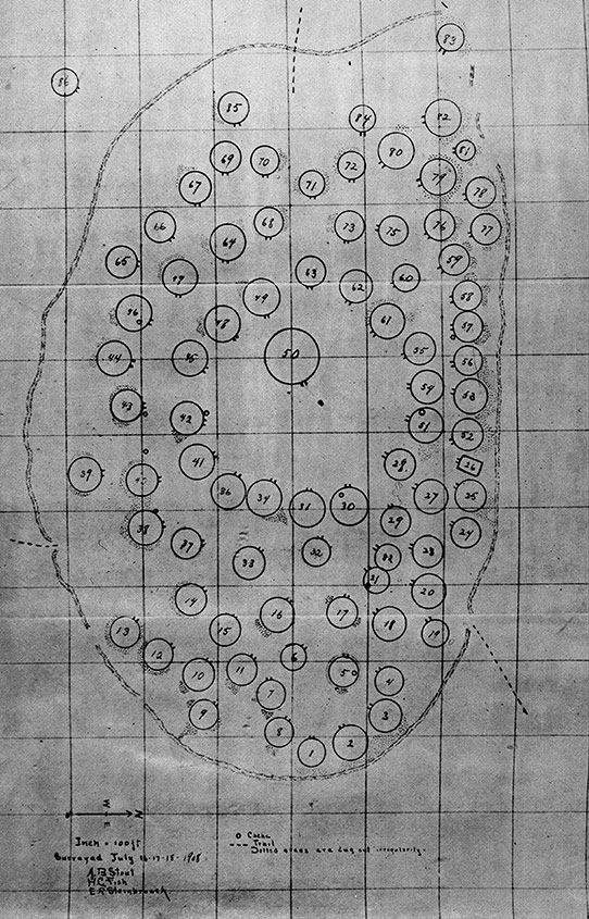
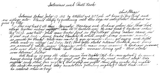
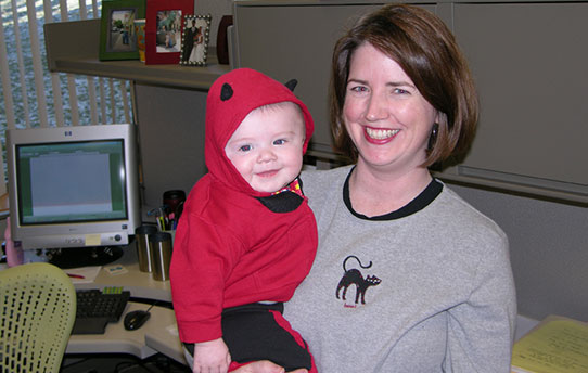
Bringing Baby to Work: The SHSND Infant-at-Work Program

I loved the Infant-At-Work Program so much that I brought both of my sons to work! My favorite aspect about the program was being able to bond with my babies after my maternity leave was over. I felt so fortunate to be able to contribute to my professional career and see my sons every day!” - Emily Ergen, SHSND Archives Specialist

This post will take you way behind the scenes, to talk about the tiniest members of our staff. Many people are not aware that North Dakota state agencies have an “Infant-at-Work Program” (IAWP). I don’t know how it works for other agencies, but I have benefited from it myself at the SHSND and thought the blog would be a good way to share about how it works here.

Employee at his work desk with baby daughter

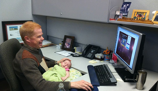
Tom Linn (Architectural Project Manager) works on his computer while his daughter naps in his lap.

Very simply, IAWP allows new moms and dads to bring newborns to work every day until the child is six months old. YES. I KNOW. Amazing, right? Since I started here in 2011, I have worked alongside at least eight agency babies, including my own daughter. The policy has some caveats, of course – the baby must be in a safe environment, you cannot travel with the baby in a state vehicle, and the baby cannot be at work if he or she is so loud or disruptive that it affects productivity (our administrators make that decision). Parents also need to provide all necessary furniture or equipment like strollers, cribs, changing supplies, etc. So while it is allowed, parents still need to be mindful and considerate. That is not too much to ask, considering what you get in return.

Employee at her computer with daughter and co-worker lying on floor playing with baby

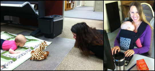
Left: My daughter did not like doing her five minutes of “tummy time” in the office! In a show of solidarity, Lisa Steckler (Historic Preservation Planner) was kind enough to keep her company.
Right: My daughter spent a lot of time in her baby carrier, which allowed me to type with both hands!

So now you might be wondering – how could anyone get any work done while they are also taking care of a baby? It’s a great question. I asked myself the same thing before I started bringing my baby to work. I was so nervous that having her at work would be stressful or affect my productivity (or that of my coworkers). But newborns mostly sleep, snuggle, observe, and eat for the first few months, all of which are things they can basically do anywhere. Don’t get me wrong – working with a baby is hardly easy. But I did learn how to type softly so I didn’t wake her if she was asleep on me, find quiet places to read my work out loud so she would be entertained, and we went for walks through the galleries when she got restless.

Employee watching her baby daughter on a foam piece

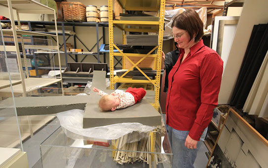
Here is Genia Hesser’s (Curator of Exhibits) daughter learning the ropes of exhibit development in the Exhibit Production room.

Usually my job is varied enough that I can do things while moving if she is in an active mood, or sit at my computer and get other things done if she is feeling content. We got into a good groove after a few weeks, where I could predict the best times during the day for me to schedule meetings, eat lunch, do standing work, make phone calls, and so on. And when you do start noticing that your baby is more active and needs more of your attention, you are typically at that 6-month mark, when it is time for him/her to “resign” from the job anyway.

Two employee's babies sitting in play area

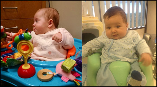
Left: Visitors to our administrative offices may or may not have noticed this little lady on the floor behind Ashleigh Miller’s (Administrative Assistant) desk! She was Ashleigh’s sidekick in answering the phone, assisting visitors, and keeping track of our leave balances.
Right: Here is another SHSND baby helping Erica Houn (Administrative Officer) with payroll and accounts.

Our agency converted our former first aid room to a nursery, complete with a rocking chair, soft lighting, refrigerator and private bathroom. There was never a shortage of co-workers willing to hold her, talk to her, or take her for a walk. In our building, you typically see a baby traveling with an adoring entourage around 10 a.m. or 3 p.m. every day, as people take their work breaks. It gives parents a rest and gives the baby plenty of social time with agency staff. My coworkers were also great about opening doors for me, carrying some of the ten bags I always seemed to have hanging off of me, and looking at me with sympathy rather than irritation when my baby cried.

My baby attended dozens of meetings in her first six months, saw her first artifact before she could eat solid food, did some exhibit planning, supervised my work on the lithic comparative collection, and helped me organize countless collections from her stroller or baby carrier. She was an attentive and agreeable sounding board, who always seemed to think that my ideas were great. Our staff even threw her a “retirement party” on her last day of work.

Cubicle transformed into baby station

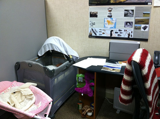
This was my version of a cubicle-nursery in 2014.

As a parent who has benefited from this policy, I am eternally grateful for it for so many reasons. First, I felt like I could enjoy my maternity leave, since I knew that the end of it did not mean the end of being with my baby all day. I was able to bond with my daughter for her first six months, with no disruption in feeding routines or constant worrying during the work day about how she was doing (which I would definitely do) . Second, she grew accustomed to being able to sleep through ANYTHING (and it stuck!).

And lastly, it made me feel a sense of support in the workplace that I have not had anywhere else. Whether it was our Historic Preservation Planner getting on the floor to do “tummy time” with her, our Grants & Contracts officer watching her while I attended a meeting, or our reference specialist mesmerizing her with sparkly things while we talked about historical records, I was never made to feel like my baby was an intrusion. She was just part of the team, and our Security guys even made her an SHSND name badge to prove it. So the next time you see one of us with a baby at the North Dakota Heritage Center, you will know that he or she is part of a tiny army of future historians who were lucky enough to get their start at the State Museum.

Employee holding her son

Amy Munson (Grants & Contracting officer) was the first parent in our agency to take advantage of IAWP by bringing her son to work in 2006. Thanks for leading the way, Amy!

Remembering Nishu: A Collaborative Oral History Project

If you were to look at a map of the Fort Berthold Indian Reservation with Arikara elders living in White Shield (North Dakota) today, they would tell you where they used to live. They would point to where their houses were, their relatives’ houses, their school, and the berry patches they walked to with their grandmothers. They would point to the churches, roads, and cemeteries, and the gardens they had to weed in the morning before they could play with their friends. They would describe these in astonishing detail. And this would be all the more astonishing because they would be pointing to the middle of the nearly 200-mile-long Lake Sakakawea. Nishu, the home they describe, has been under water since 1954.

Even, even to this day, if I jump in a boat, and I take that boat out on the lake, invariably I will go downriver. Go down the lake. Pretty soon I’ll be circling around and telling my grandkids or my kids, “I used to live right under this water right here.” (Almit Breuer, former Nishu resident)

Map of Fort Berthold

Map of Fort Berthold communities inundated by the Garrison Reservoir, showing previous river channel and current lake boundaries. (SHSND AHP Files)

Nishu was a 20th-century settlement on the Missouri River, established by the Arikara in the 1890s. It marked an important chapter in Arikara history, in which this Native nation simultaneously grappled with the effects of the U.S. government’s assimilation policies and maintained many ancestral traditions, such as corn agriculture. In the 1950s, they watched as the place they had made their home was slowly swallowed by the newly constructed Garrison Reservoir. Although it is no longer accessible, it continues to be a significant heritage place for Arikara people today.

Mary Bateman

Project participant and former Nishu resident Mary Bateman (W. Murray)

Very little information about Nishu exists in the written record. Furthermore, the people who remember living there are in their 70s, 80s, and 90s. This created a sense of urgency about documenting Nishu before people’s memories and experiences of it were gone forever. Younger generations have no visual cues for remembering Nishu, because they have only known that area to be a lake. This creates a serious disconnect between generations who have experienced the landscape in completely different ways. Since preserving the physical remnants of this place was not possible, we sought to preserve its intangible history – the memories, knowledge, and experiences of the people who knew it best.

Men looking at map

Arikara elders Jerry White, Sr., Rodney Howling Wolf, and Duane Fox look at a map of Nishu. (W. Murray)

In 2014, the State Historical Society collaborated with the Arikara Cultural Center (ACC) in White Shield to conduct an oral history project. The goals were multifold, but the priority was to create a local archive of Nishu memories to benefit the contemporary Arikara community. Namely, we wanted younger generations to have a way to access this chapter of their past in the absence of physical reminders on the landscape. We are grateful to Dorreen Yellow Bird, elder liaison for the Arikara, for her support as she helped us connect with people who used to live in Nishu and the neighboring Elbowoods (also underwater).

Wendi Murray interviewing Joyce Nolan

Interviewing Joyce Nolan, former Nishu resident. (W. Murray)

Over several months, Dr. Brad Kroupa (ACC) and I interviewed 15 people, most of whom lived in Nishu. Some were either familiar with Nishu or had relatives who had told them stories about Nishu. Thus far, we have collected more than 30 hours of video and audio footage describing life in Nishu. Interviews recount everything from the central role of horses in transportation to the persistence of traditional kinship roles to what it was like receiving initial news about the Garrison Dam development that would destroy their homes. For example, we learned exactly how much kids dreaded having to help their parents weed the garden, the specific ways Arikara women prepared corn, whose father had a beautiful singing voice, the significance of military service in Arikara ceremony, the Nishu school bus route, who accidentally set their grandparents’ barn on fire, whose relatives had knowledge of healing, and what aspects of Nishu life people miss most today (and much more).

What we heard most strongly is that Nishu residents took care of one another. Despite the considerable distance between houses (owing to allotment policy), people visited one another often and unannounced, shared in subsistence labors such as gardening and cattle raising, and were connected by a strong sense of familial responsibility. People’s nostalgia about Nishu was tied to feelings of interdependence and support. Listen to this audio clip from our interview with Magdalen Yellow Bird, talking about the importance of visiting in Nishu.

Arikara Congregational Church

Arikara Congregational Church in Nishu. SHSND Archives 0041-0260.

Understanding the Nishu experience casts new light on how traumatic the Garrison Dam was for Fort Berthold residents. The Garrison Reservoir split the reservation into five segments. Short visits to relatives on horseback became burdensome, hours-long car rides. The flooding of the most fertile agricultural land meant that corn agriculture–central to Arikara lifeways and identity for centuries– was no longer possible. The relocation also forced the Arikara into participating more fully in a cash economy, which prioritized self-sufficiency and individual property ownership. This undermined the communal aspects of their subsistence traditions and contributed to the partial erosion of the familial connections and obligations that had served to foster a sense of community in Nishu.

Mrs. Sitting Bear gathering corn

Mrs. Sitting Bear (Arikara) gathering corn (date unknown). SHSND Archives 10190-00791.

The Arikara Cultural Center is now using what was learned in the Remembering Nishu project to start community-building and wellness initiatives in White Shield, including the development of a community garden and youth research projects. In a few months these transcripts, audio, and video files will be available for you to review in full at the State Historical Society in Bismarck and the ACC in White Shield. In them, you will discover Nishu’s vital role in Arikara history and find insights into the human experience that extend beyond North Dakota. Through Nishu we understand the complex impacts of landscape loss and the role of tradition in creating healthy communities.

We are grateful to all project participants for being so generous with their time and knowledge, for their commitment to the preservation of Arikara heritage, and their profound concern for the well-being of future generations.

Getting to Know Star Village

I was doing some research on Arikara settlement the other day, and started going through our flat files. Our flat files contain many of the large archaeological site maps and photo plates that we have accumulated since we became an agency. Many of them, such as maps by archaeologists E.R. Steinbrueck and A.B. Stout, are some of the oldest maps we have of earthlodge villages along the Missouri River. I turned to this collection because I wanted to see what A.B. Stout had written in his notes about Star Village, the village that the Arikara people occupied before they moved to Like-A-Fishhook Village in 1862.

Flat files in Archaeology division

Our division’s flat files, containing oversized site maps, photo plates, aerial photos, plan maps, etc. It is a good thing that I love going through these files, because one of my responsibilities this year will be to digitize, scan, and organize this whole collection.

I should note that Stout didn’t stick with archaeology – he actually ended up moving to New York and becoming a renowned botanist, best known for his expertise in plant genetics (specifically, the hybridization of daylilies). But before he became a leading plant scientist, he worked for our agency mapping and excavating village sites.

My research focuses on the settlement of the Arikara people at Like-A-Fishhook. A few weeks ago, I was agonizing over the function of log cabins mapped at that village – some of them seemed like they might be dwellings, but others were too small, too compartmentalized, or attached to an existing earthlodge. Could some of them have been used to stable horses? Or maybe some were used as storage annexes? Normally, an archaeologist could look for answers by excavating these features at the site. But that is not an option for me. For some reason, most of the research questions I am passionate about revolve around sites that were permanently inundated in the 1950s by Lake Sakakawea. I realize that this is not ideal. Am I a glutton for punishment? Maybe. But I am also a collections manager, and believe that with some creativity (with approach, questions, and methods), paper records and artifact collections still have much to tell us about sites we no longer have access to.

Pop-up models of Like-A-Fishhook Village

Proof of my commitment to Like-A-Fishhook – Collections Assistant Meagan Schoenfelder made these pop-up models of the site for my birthday last week, based on a ca. 1868 sketch by Maj. Gen. Regis De Trobriand (left) and a map drawn by a former resident, Martin Bear’s Arm, (right).

As an alternative to excavation, I am relying on archaeological and historical maps. I thought I should check out the architecture at Star Village, which was built in spring of 1862, across the river from the Mandan-Hidatsa settlement at Fishhook. It was also the site of a battle with the Sioux after that tribe’s dealings with a resident white trader went horribly wrong. The village was burned the same year, and the Arikara moved across the river to Fishhook. Here is the map of Star village, based on surface indications, drawn by A. B. Stout in 1908.

Map of Star Village

Map copy of Star Village, 1908. (A.B. Stout, H.C. Fish, and E.R. Steinbrueck).

Opening that folder was the best part of my day, because I did not find just maps. I found that Stout had also kept notes on the sites he mapped. For this particular one, he mentioned that he was working with a former resident, an Arikara man named Bull Neck. Bull Neck assisted with the identification of the round earthlodges (drawn as circles on the map), speaking to Stout and SHSND Curator H.C Fish through an interpreter named Alex Sage. Included in these notes are details Bull Neck provided regarding who lived in 22 of the 94 lodges. Bull Neck did happen to mention that the only rectangular building at the site was not a dwelling, but was used by a man named Sun to stable his horses (No.26).

This is the only written documentation I have found indicating this possible use for log cabins. These cabins become much more common in the 1870s at Like-A-Fishhook, and other records indicate that they were used as dwellings as well – understanding this architectural transition from earthlodges to log cabins after European contact is something I plan to investigate with colleagues next year, after my dissertation research is complete (and by the way, I can’t believe how many research ideas I come up with when I am supposed to be focusing on finishing another project).

Some other highlights from the notes, relating to the numbered lodges. Each number corresponds to a lodge on the map:

No. 9 - The residence of the white trader (name unknown), identified by Bull Neck as the origin of the battle leading to the site’s abandonment

No. 30 – Lodge of White Eagle, great grandfather of Alex Sage (the interpreter we used). He held or kept pipe of peace now in possession of Sitting Bear. His wife was Old Woman. This was the lodge of laws and council.

No. 32 – Lodge of White Shield, head man of this village. His wife was Corn Pile.

No. 51 – Lodge of head of all medicine men named Soup. Soup’s father was Holy Bear. Family – a site and adopted child, Bear Goes Out.

No. 54 – Lodge where the bear was represented – everything representing the bear was kept here – bear skin, cloth, etc. No one lived here – put up tent tepee in front for preparation for dance.

No. 83 – This was the first house built in village – was lodge of only Mandan in village his name was Chief. Had wife – one daughter and one son named Long Tail.

Part of interview with Bull Neck

Excerpt of hand-written interview (copy) with Bull Neck, conducted by Stout and Fish on July 17, 1908.

In the interview with Bull Neck, we also learn about his family, as well as the battle that led to the site’s abandonment.  As an archaeologist, I am much more accustomed to using data to make generalizations about human behavior. These notes remind me that this “village” was made up of individuals who all had their own relations, memories, and experiences that archaeologists can’t usually capture in their interpretations. What we think of today as abstract “archaeological sites” were once homes – familiar landscapes and communities where people’s lives unfolded in real time.

I know Stout’s passion was plant genetics, but I still need to give him a shout-out for his brief foray into archaeology. This little-known gem in our flat files contributes much to our understanding of Arikara village life.

MISSION I̶M̶POSSIBLE: A Man, His Camera, and 35,000 Artifacts

We have been promising for a while that we are going to digitize our archaeological collections – all that really means is photographing them and filing that digital photo in our electronic catalog. And we have needed to photograph one particular collection for a while, which contains upwards of 35,000 artifacts. We have a pretty good camera, we have a new photo station, and we have all the artifacts organized and ready to go. But we usually have about ten or more other projects going on at the same time. How were we going to find the time and staff to photograph that many artifacts? It seemed impossible. And then in walked David Nix.

Dave is a retired biology professor from the University of Mary and an accomplished photographer. Though he did help us out sorting artifacts as a volunteer back in 2006, it had been a while since he had worked with our division. He had just bought a new camera and wanted an excuse to try it out. He offered to volunteer for three hours, three days per week (keep in mind that this is more than an entire work day every week that he dedicates to preserving North Dakota’s history). Thanks to him, our collections staff members have become digitizing fiends! Seriously. We can’t stop taking photos.

Photographer Dave Nix

Photographer Dave Nix sets up his next shot at the photo station in the Archaeology and Historic Preservation division’s archaeology lab.

Why is it important to have photos of our artifacts? First, it is good for their health! It is important for our staff to have instant (visual) access to our collections without having to dig through boxes looking for a specific artifact or a good example of a certain type of object. Repeatedly handling fragile artifacts increases the chances of wear and breakage.

Second, it allows us to track an object’s condition over time. We can compare a photo of an object from 10 years ago with the object today and see, for example, that it remained intact while on loan to another museum, or maybe fluctuations in humidity have caused cracking or damage.

Third, we can attach a photo to a digital artifact record that details what the object is, where it is from, and its relationship to other features and artifacts at the archaeological site. Having the photo attached directly to this information is unbelievably helpful when you are preparing for exhibits, conducting an audit, engaging in tribal consultation, developing interpretive programs, solving collections mysteries, or doing scientific research.

Prepping potery sherds

Dave Nix and Collections Assistant Meagan Schoenfelder prepping some pottery sherds for the next photo.

Finally, photos give people who don’t work with the collections access to them. We send them to researchers. We send them to conservators to diagnose condition issues. We use them in our Archaeology Awareness posters, and for presentations at professional conferences. We use them in publications. We send them to educators for inclusion in curriculum materials. We post them on our Facebook page. And we will eventually make them accessible through our website.

So when Dave comes in, here is what usually happens: first, we pull the boxes to be photographed that day. We try to keep it varied so no one gets burned out photographing a thousand horseshoes or square cut nails in a single afternoon (Though during the occasional All-Rusty-Iron-Axe-Heads-All-Day! sessions, Dave is shockingly good-natured). The archaeologist scheduled to be the photo assistant for that day decides what to photograph, writes the accession number on the photo scale, and tells Dave what details need to be documented. Depending on the object, this may include flaking scars, ceramic decoration, maker’s marks, etc. Dave adjusts the lighting and lenses, optimizing the shot for that particular artifact.

Boxes

A stack of boxes waiting in line to be photographed.

After three hours, we upload them to a server set aside for collections photos (as you can imagine, this requires a LOT of data space). Then Nancy, our Division’s Administrative Assistant, labels the files, crops the photos to reduce the file size, and attaches them to the appropriate artifact record in our cataloging program. She does this not only with astounding speed and attention to detail, but often whispers, “I need more pictures!” as I am walking by her desk.

Since we started last fall, we have photographed nearly 7,000 artifacts. Only 28,000 to go! Then we will take Dave to Dairy Queen, which is all he asked for in return. When the time comes, I hope he is ready to eat a serious amount of ice cream.

See some of Dave’s recent photos of our collections below!

Gastropod shell beads and bottle of Wakelee's Camelline

Left: Gastropod shell beads. Note the hole that has been punched through the outermost whorl of each shell.
Right: A bottle of Wakelee’s Camelline. This product was marketed to improve and beautify the complexion.

Pocket watch and historic doll parts

Left: A metal and glass pocket watch from an historic farm site in Emmons County.
Right: Historic doll parts have to be the creepiest thing we find in the field or in collections. This doll’s face looks especially menacing to me. I have coworkers who feel much more strongly about the creepiness of doll parts than I do, and who will not be happy to see that I have included them here!

Ultrathin biface and pottery rim

Left: Ultrathin biface from our Lake Ilo collection. Incredible flintknapping skill is needed to make a large biface as thin as this one without breaking it. If you turned it on its side, you would see it is about 0.5cm wide.
Right: Pottery rim from a Plains Village site on the James River in Stutsman County.

Our Collections, Coming to a Computer Near You…

If you are like me, you think that software, as a general topic of discussion, is boring. Few people interested in history and anthropology are drawn to blog posts about software (notice that I didn’t include it in my title, for fear of you abandoning me before I could get a word in edgewise). But what if that software allowed you (literally, you) access to our collections from exactly where you are sitting right now? What if it connected close-up photos of artifacts directly with that object’s records? What if it made collections research more possible, allowed us to put together exhibits much more easily, and allowed us to search across multiple collections at once?

Each of our divisions currently manages its collections in separate types of programs and databases. For example, a researcher interested in Fort Clark would currently have to come to the Archaeology and Historic Preservation Division to search separate databases/shelves for artifacts and excavation notes. Then she would go to the Archives Division to search for historical records and photos associated with the site. Then she might want to check with the Museum Division to see if there are historical objects that relate to the site but were not found archaeologically.

We are happy to report that this wild goose chase is all about to change!

Re:discovery software

Example of an artifact record after our customizations were implemented. All the fields you see correspond directly to either a field that was already in our existing databases or a field we always wished we had.

The SHSND has recently purchased Re:discovery, software designed specifically for museum collections management. Why is this important? Managing any collection requires us to have updated and easy-to-access information about each object. An artifact record might include where it came from (i.e., Double Ditch Indian Village), where on the site it was found (i.e., “floor level, House 4”) who donated it, its function, its condition, its characteristics, pictures, etc. Under the direction of our astonishingly patient and meticulous IT administrator (whom must secretly feel that working with historians who cling fiercely to ten almost-identical versions of the same database because they are afraid to throw anything away is maddening), we are implementing this software in phases. Our AHP Division was the first up, and here is how it went down:

  1. First we had to create our artifact record screens. Re:discovery has a standard one already, but some of the fields did not work for our data. So we requested customizations. We wanted the names of certain fields changed, we wanted certain fields to only allow certain entries, we wanted dates formatted a certain way, and so on. This was made more complicated by the fact that we curate for federal agencies, which have their own database entry requirements. To keep everything organized, we created a “mapping document” that accommodated all SHSND required fields, all federally required fields, and were formatted to receive our existing data in ways that would not create a huge mess or data loss. This process took several months of making requests and corresponding with Re:discovery to figure out what was possible.
     
  2. Screens customized and approved! Time to move on to data conversion. This just means that we had to move the artifact data we have put in a bunch of disparate Access databases over the years into a single directory in Re:discovery. Let’s be honest – this was a nightmare. As with most institutions, people entered different types of data in different ways over time. So in one database, for instance, the location information (i.e., Excavation Unit 10) might be in a field called “location,” and in another database for a different collection, it might be in a Description field. So you can’t just say “all Description data in our Access fields can be migrated into the Description field in Rediscovery” (because you want location data in your fancy new Location field). So you have to reconcile all those discrepancies before you can migrate data. And we are talking tens of thousands of records. We also had to make decisions about what information got moved and what could be dropped. For example, some collections staff would write their thoughts in the Description field, like “I have never seen one of these before” (Is this really informative and worth saving?). In some cases the entry to describe the object tells you more about the context of its use rather than its function. For example, instead of calling a military button a “button” in the Object field, it said “Military” – not ideal when you want to search your database for buttons! This phase forced us to make some standardizations and changes in our cataloging procedures. I definitely had moments where I felt like we were in an endless loop of adjusting and converting our data, and maybe I just had to accept that this was what the rest of my life was going to be…

    Re:discovery softwareA list view in Re:discovery. Instead of viewing individual artifact records, you can scroll through lists of artifact records, all of which can be filtered by whichever fields will give you the info you need (i.e., I can search for all artifacts from the Larson Village site, or all the bone beads from Larson Village, or all the scapula hoes from Larson, Boley, and Sperry Villages. The search options are endless, which brings tears (of unabashed joy) to my eyes.
     
  3. At last, data converted! But we couldn’t just assume it all migrated perfectly. We had to check the data conversion to make sure data migrated safely and was not lost. This amounted to tens of thousands of records, and checking each one individually was not possible. Instead, we calculated a statistically representative sample for each database, which means we ended up checking about 200 to 300 randomly selected records for each one (amounting to about 1000 entries). We compared every field (thirty or so) from the old database with those in the new and noted any inconsistencies, formatting weirdness, mix-ups, etc. Any problems we found in the conversion we communicated back to the IT administrator and Re:discovery project manager, who adjusted the program or data as needed.

    Stone scrapers
    Some artifacts we have recently entered into our new system – stone scrapers, a historic bottle, and a pottery sherd from the Woodland period decorated with a cord-wrapped stick.
     
  4. Home stretch! Last steps were to set permissions for which staff can access or modify the data, document problems with our own data that this process helped us to discover, and get formal training on how to use the program.

Historic bottle

As of last month, we began actively cataloging multiple archaeological collections, attaching digital photos of artifacts, geeking out on the program’s functions, and forcibly stopping ourselves from doing cartwheels in the lab from excitement that we can now do this work in one place so efficiently. Next up is the Archives Division, followed by the Museum Division. After that, we will work on getting the Web Module up and running so the public can search our collections online, complete with images. Our goal is to bring the collections to you. You can see for yourself all the objects we are preserving, without having to leave the comfort of wherever you are sitting right now. Stay tuned!

Pottery sherd

The Social Side of Archaeology

To illustrate a short video segment about archaeological collections work, a co-worker recently asked me for pictures of fieldwork I did during graduate school. Only after I sent those pictures did it occur to me that they probably needed a bit more explanation. That is because most of them are not the pictures you would typically associate with fieldwork. There are none of me working in an excavation unit, or walking transects on a survey, or looking at pottery through a microscope. I mean, I did all of those things in grad school. But most of these pics are of me talking to people. And it was the most exciting fieldwork I have ever done.

Viewing a map

Viewing a map with an elk hunter in the Rockies (M. Zedeno)

Many archaeologists develop a particular expertise in a specific material class. Some are ceramicists, some are malacologists (shell), some are experts in faunal remains (animal bones) – the list goes on. And we need them all! But I had a transformative field school experience in Arizona back in 2003 when I was just getting started in archaeology that led me down a slightly different path. We learned all the usual things you learn in field school – excavation techniques, survey, mapping, lab analysis, etc. But the focus of the field school was on tribal collaboration and ethical archaeology. We had guest speakers representing different tribes in the area, who shared their views on the past, the importance of oral tradition as a historical resource, and their perspectives on the sites and objects created and used by their ancestors. We also heard from archaeologists who had partnered with Native American tribes to develop research projects that increased archaeological knowledge, but also addressed topics that were meaningful or important to that community. I came away with the feeling that archaeology should have as much to do with living people in the present (also known as descendant communities) as it does with how their ancestors lived in the past. I was still interested in objects, of course. But I was most interested in how descendant communities see and think about those objects.

So what about those pictures of me talking to people? They were from projects run by the Bureau of Applied Research in Anthropology at the University of Arizona. They focus on interviewing tribal elders and cultural specialists in the Northern Plains about their knowledge of specific resources – plants, animals, landscapes, and archaeological sites. For example, rather than do a walking survey by transects, we did survey on horseback with Blackfeet elders who showed us historic elk hunting camps. They gave us information about how they were set up and who used them – things we never would have known had we mapped them alone. And here is some unsolicited advice: do not ever let your first horseback riding experience be several days on the edge of dizzying cliffs on the Continental Divide in Montana’s grizzly bear country with your dissertation advisor, who you were hoping would see you as a confident, adventurous, and roll-with-the-punches kind of research assistant.

Remains of barrel feature and archaeological survey on horseback

Left: The remains of a barrel feature found at a historic elk hunting camp in Montana (M. Zedeno)
Right: Archaeological survey on horseback (M. Zedeno)

In addition to looking at plants under a microscope, we interviewed Mandan and Hidatsa elders about the cultural significance and traditional uses of particular plants. This allowed us to provide a report to the National Park Service to help them come up with resource management plans that are sensitive to the plant-related needs and beliefs of native communities. For a project about eagle trapping, we did not look for eagle bones in faunal assemblages. Instead, we visited eagle trapping sites with elders who still hold eagle trapping rights, and learned about why certain types of objects and features are found together. We also learned how those sites can be more respectfully managed.

Working with tribal consultants

Working with tribal consultants from Fort Berthold on the University of Arizona’s Missouri River ethnobotany project (M. Zedeno)

So while I love objects as much as the next archaeologist, a good part of my archaeological training has actually been in ethnography and interviewing. As all of my friends were creating GIS models or comparing radiocarbon dates, this used to find me mired in an angsty anthropological identity crisis (I’m an archaeologist! No, I’m a cultural anthropologist! I’m neither! I’m both! I’m an imposter! Ahh!). But I am over that. And to be frank, I am pretty darn excited about what I do these days.

Revising a report and viewing a documentary

Left: University of Arizona researcher Dr. Maria Nieves Zedeno and the Tribal Historian of the Mandan, Hidatsa, and Arikara Nation, Calvin Grinnell, revise a report at the Three Affiliated Tribes Museum (W. Murray)
Right: A viewing of the SHSND-produced documentary, People of the Upper Missouri: The Mandans at Fort Berthold Community College in New Town, ND (W. Murray)

There are lots of things to do at the SHSND that are right in line with this – whether we were working on developing the Early People’s exhibit, producing the Mandan documentary, interpreting our historic sites, consulting with tribes on the significance of particular objects, or conducting oral history interviews. Somehow they all involve the links between archaeology (the tangible stuff of the past) and ethnography (people’s worldviews, stories, practices, and traditions).

For example, we are currently collaborating with the Arikara Cultural Center to interview people about life in the bottomland communities (Elbowoods, Nishu, etc.) before the construction of the Garrison Dam in the 1950s. Now that these sites lie beneath the waters of Lake Sakakawea, the physical sites that would normally be a part of the archaeological record are gone. But documenting the collective memories of what it was like to live there are vitally important to the Fort Berthold community.

Interviewing Dorreen YellowBird and Artist Rob Evans painting the Double Ditch Indian Village mural

Left: Interviewing Dorreen YellowBird at the Arikara Cultural Center in White Shield, North Dakota about her memories of living in Elbowoods before the construction of the Garrison Dam (K.T. Kroupa)
Right: Artist Rob Evans worked with SHSND archaeology staff to create a depiction of the Double Ditch Indian Village as it would have appeared around AD 1550. Much of the detail derives from archaeological excavations and ethnographic records. At the request of Alyce Spotted Bear, we also included audio components throughout the exhibit (including this cyclorama) that allows visitors to hear people singing and speaking native languages.

When I moved here, I was afraid that a job in collections would be less about people, and more about things. Luckily, that is not even close to how it has worked out. Working in the Archaeology and Historic Preservation Division of the SHSND on these and other projects has only cemented my belief that the present – native voices and perspectives on the past - is not peripheral to “real” archaeological work. It is, in fact, an integral part of it.