Writing for Dakota Datebook
 If you are a fan of Prairie Public Radio here in North Dakota, you may already be familiar with the “Dakota Datebook” program. It airs five times a day, every day, and features snippets of North Dakota history that relate to that date in time. The posts pop up all over—sometimes reprinted in newspapers—and last year, a selection of dates were published in book form!
The State Historical Society of North Dakota has been a longtime partner in this program. A handful of past Archives interns have written specifically for this program during their time with us (such as Jayme Job, Tessa Sandstrom, Annie Erling, Maria Witham, Carol Wilson, and Alyssa Boge). Some of our staff serve as part of the editorial board. Also, a few of us write for the program—and as a result, we have ended up helping with a few different series that have formed.
Avid listeners to the series will likely remember these series. While there have been a few more, unconnected to the State Historical Society (such as Steve Stark’s series on Theodore Roosevelt from this past summer), a good number have been written by staff here:
- One series, mainly written by Jim Davis, (though I assisted on one or two dates), was written for the 50th National Historic Preservation Act. Staff in our Archaeology and Historic Preservation Division provided some ideas for those datebooks.
- Jim Davis also took the lead on and wrote a MASSIVE number of entries documenting and commemorating the anniversary of World War I, as well as a “Countdown to Statehood” series for the 125th anniversary of North Dakota’s statehood.
- And now, I am writing my first series celebrating the 100th anniversary of the passage of the 19th Amendment—a series on women’s suffrage! And what better time to discuss this series than now, during National Women’s History month?
Now, I wouldn’t say I’m an expert on women’s suffrage, but writing for the series means you do a lot of research that takes you off in many different directions, and you learn a LOT of details—and get very familiar with it. In fact, I think you kind of start to LIVE the history. And the history is fascinating! Suffrage bills were present in many legislative sessions. However, not all men or women supported the idea. Prior to obtaining suffrage fully through the 19th Amendment, women did get some limited voting rights in North Dakota. Gov. Lynn Frazier alone would sign several bills related to women’s right to vote, including the ratification in December 1919. And despite all of this, women also still served in elected public offices, many quite early on. Such as Laura Eisenhuth—she was the first woman elected to state-wide office in North Dakota and the first woman to hold a state superintendent’s position in the United States in the 1890s.
The resources are out there, and it’s been a treat to find them and bring them together. I’ve read through old House and Senate journals when women’s suffrage had been on the agenda. I’ve been following threads concerning suffrage through different newspapers. (Thank you, Chronicling America!) I’ve been looking at posters and illustrations depicting the fight for suffrage—both here, and through the National Archives collections. These have been invaluable resources during my first few entries.
I’m also lucky to have a timeline I can follow, which the North Dakota Women’s Suffrage Centennial Commission put together, that gives me some direction if I am failing. Though I always have enjoyed writing about obscure details, the whole history helps to ground these stories and is also necessary for the series.
And then, to add icing to the cake, I am reading these entries for the program. Since these stories are about women, Prairie Public wanted to use a woman’s voice for the entries. I have never recorded something for radio before, so I am honored every time that I am able to bring a voice to these words.
This is a really fun, very different, and interesting part of my job, and I look forward to continue working on this project through this partnership.
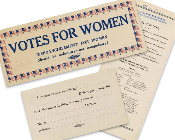
These items, from our ephemera collection, show items for and against suffrage. Note that the North Dakota Association Opposed to Woman Suffrage consists of all women officers. SHSND SA 11354-Womens_Suffrage
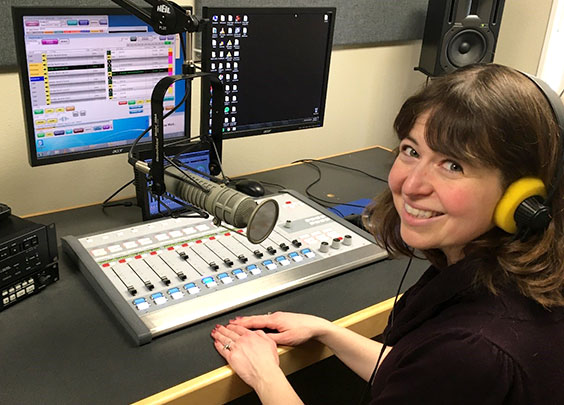
Sarah Walker at Prairie Public Station in Bismarck, ready to record. The audio is actually recorded long-distance in Fargo, where it is edited and made ready to air.