Ask-an-Expert Program Connects North Dakota Studies and State Historic Sites
When I first started with the State Historical Society of North Dakota, one of the tasks given to me was connecting the Chateau de Mores to North Dakota Studies, an online resource for students, teachers, and lifelong learners that explores our state’s people, places, events and fascinating history. It was an assignment that never made much sense to me. Good interpretive programs highlight a resource, whether it is a tree, a historic house, artifact, or just the site itself. My assignment was making North Dakota Studies the resource when it should be the Chateau. It was emphasizing the wrong thing. So what was the fix? It seems simple; we needed to make the sites a resource for North Dakota Studies. It needed to be something that helped teachers and connected to themes found within the North Dakota Studies curriculum. While this task has many obstacles, the solution has us excited.
Currently, our sites serve teachers as a field trip destination. Unfortunately, history does not always happen in convenient locations. Some sites are remote, and while we can serve students who live close to the site, what about those who don’t?
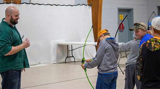
Photo of Fort Totten Site Supervisor Kyle Nelson teaching a session on archery as part of the Whitestone Hill Education Day.
In a past blog, I mentioned that we were developing virtual field trips at sites. It is a good idea. How else will we get students from Abercrombie to experience a site like Fort Buford on the opposite side of the state? Plus, without the travel requirement, students can participate in several of these programs with different sites across the state. But there are problems to be solved. The biggest holdup is the limited internet at sites. It is not much of a field trip if all you can see is the office area. You want to be able to go into the underground capsule at Oscar-Zero Missile Alert Facility at the Ronald Reagan Minuteman Missile State Historic Site. Plus, not all the buildings are heated. I once did a Facebook Live video from inside the Chateau in the middle of winter. I was shivering by the end.
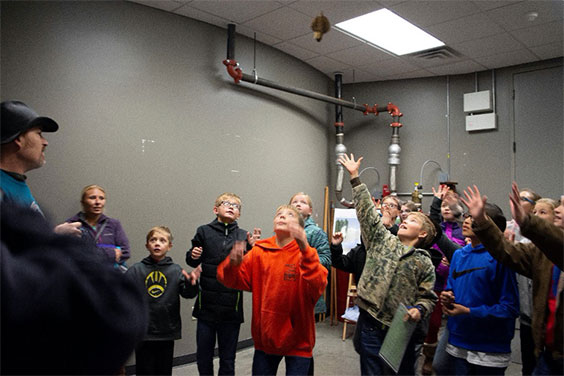
Missouri-Yellowstone Confluence Interpretive Center Site Supervisor Joseph Garcia leads a group of students through a hands-on activity focusing on how biologists learn about bird habitats from catching birds. This program was part of the Project WET education day held at the site.
With the problems identified, what is the solution? While we still want to host virtual field trips eventually, right now we could look at a different kind of virtual offering. Currently, sites are working on a program that we call Ask-an-Expert. We are fortunate to have staff that is passionate about their site. They read books and articles and use downtime to conduct research. Some have even translated books from other languages to learn more about an aspect of their site. Allowing students to ask these experts questions could be a powerful interaction for the classroom. There is a genuine cool factor in getting to speak to an expert, and it always seems to carry more weight. Sure, I could teach a class about space, but it would mean so much more coming from an astronaut.
Here is how it would ideally work. Our sites have produced a list of themes related to their sites that tie into the North Dakota Studies curriculum. Teachers can use this list to select a site that fits what they are covering in class. After making a reservation with our site staff, the teacher will introduce the topic to the class. The students craft their questions, and the teacher sends them in advance to the site staff. Having the questions will allow the site staff to pull together resources such as photos, videos, and artifacts that they can use to answer these questions. It also guarantees that students will have questions to ask. On the day of the meeting, students get to ask their questions to the site staff who answer them using their knowledge, historical accounts, and the resources gathered.
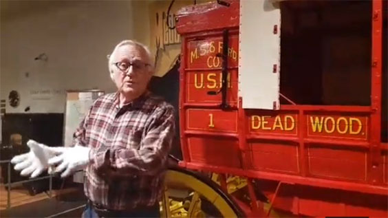
Screenshot from one of the Chateau de Mores Facebook Live videos, but a great example of how an Ask-an-Expert program would look to students.
We are excited by the potential of this program. We have done a few test runs so far, and the results were fantastic. One of the most impressive things was that in the first wave of questions, we would often see basic things asked, but while they were getting those answers, the teacher was writing down questions that were coming up during the responses. This second wave of questions, when asked, often showed some historical analysis that was happening in the minds of the students. They were thinking critically about what they are hearing. A program like this encourages students to think about causality (Why did we need to spread out the launch control facilities in the missile field?) and conflicting accounts (Did the Marquis de Morès kill Riley Luffsey?). We want sites to inspire critical thinking, and this program helps achieve that goal.
We originally planned to do a beta test of this program this past spring, but COVID-19 changed that. We are looking to try a beta test this fall and roll it out in full this winter. We hope to work out any issues and get feedback from teachers. While there may be a fee for this program in the future, participating in the beta will be free of charge. If you teach North Dakota Studies and are willing to give this program a try, please feel free to reach out to me, and I will help connect you to our experts.