


Archaeologists have been seeking higher vantage points to photograph and map archaeological sites for decades. Cameras mounted under balloons or kites, cameras in aircraft or powered parachutes, or photos taken from ladders, mechanical lifts, or even a slight hill — archaeologists have used them all at one time or another to gain an aerial perspective and document site excavations.
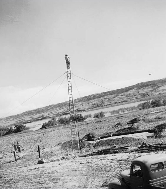
Some early methods of photography used by archaeologists were not for the faint of heart. A fully extended ladder stabilized by wires was used to photograph excavations at the Oldham site located in Charles Mix County, South Dakota. (River Basin Survey photograph 39CH7-405).
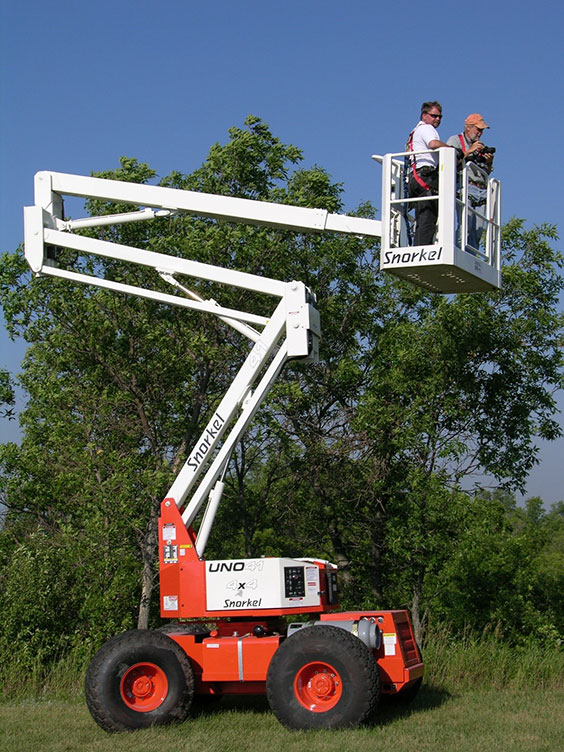
Stanley Ahler of the PaleoCultural Research Group and Lloyd Jensen of the State Historical Society of North Dakota use an articulating boom lift to photograph excavations at Menoken Indian Village State Historic Site in August 2005. (Note: Both men were wearing a protective safety harness.)
A relatively new method of mapping features at archaeological sites is drone mapping. Since 2017, I’ve written about flying the State Historical Society’s quadcopter (or “drone”) to photograph state historic sites multiple times. Most recently, I’ve written about using our drone to photograph Cannonball Stage Stop and Fort Mandan Overlook State Historic Sites.
Fort Mandan Overlook offers a great example of using a drone to generate a highly detailed surface map of features (such as house depressions, fortifications ditches, or topography) present on an archaeological site. The aerial images are processed using specialized software. State Historical Society archaeologists drone mapped the Fort Mandan Overlook site on July 25, 2019.
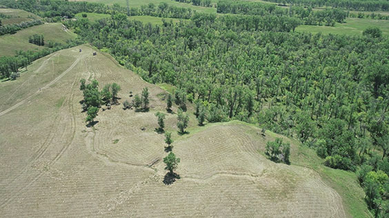
Aerial image of Fort Mandan Overlook State Historic Site in McLean County, North Dakota, taken by quadcopter on July 25, 2019. The fortification ditch visible in this image was a defensive structure constructed sometime in the late-18th to mid-19th century. The site was initially occupied as early as the 1300s. The site overlooks the former location of Lewis and Clark’s Fort Mandan, which was washed away by the Missouri River soon after the expedition passed through the area.
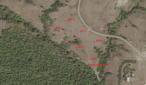
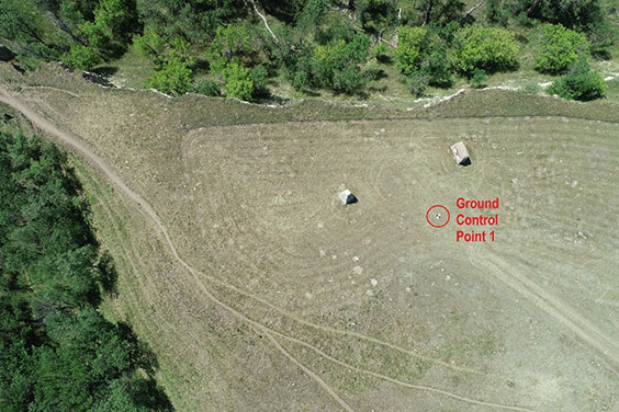
To prepare for a drone mapping mission, State Historical Society archaeologists established a series of “ground control points” at the site using a centimeter-level accuracy Global Positioning System (GPS) unit and ground targets. The targets help to accurately align the images captured by the drone and supplement the GPS coordinates tagged to each of the images.
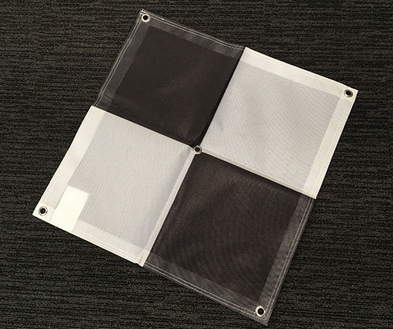
Six of these targets were placed on the ground surface at the site, and centimeter-precise GPS coordinates were collected prior to mapping.
Prior to flying the drone at the site, a detailed “mission plan” was created using Pix4D capture, a software specifically designed for drone mapping. The mission plan directed the drone to fly in a grid pattern over the site area at a specific altitude and collect images of the ground surface that would be mosaicked or “stitched” together later. The resulting 356 images are at a very high resolution, and each image has extremely detailed locational information associated with it.
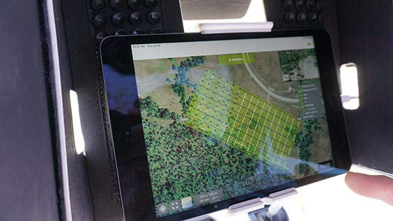
An image of the Pix4D Capture software during our “mission” at Fort Mandan Overlook. An aerial image of the area serves as a basemap. The mission grid is visible, and the green dots indicate the position of collected images.
One of the 356 images collected by the drone at Fort Mandan Overlook. This image is in the southeast corner of the site. The original image was also tagged with GPS coordinates.
After the grid mission was flown, the images collected were processed using photogrammetry software called Agisoft Metashape. Photogrammetry is the process of obtaining information about objects or the environment by analyzing and interpreting photographic images. The software corrects the inherent distortion introduced when we photograph three-dimensional objects (like artifacts or the ground surface), and then displays the images on a flat surface (like a computer monitor or a printed page).
In this case, the images used in an analysis of the surface of the Fort Mandan Overlook site were those collected by our drone. Photogrammetric image analysis is an area of research the State Historical Society’s Chief Archaeologist Andy Clark is quite familiar with, and he processed the 356 overlapping images collected using this specialized software to produce measurably accurate three-dimensional models and photographs. I’ve included a couple brief descriptions below.
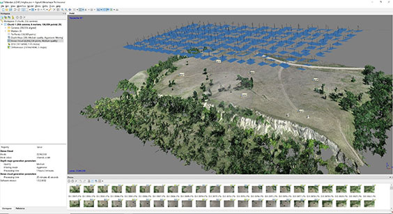
An image from the photogrammetric software used to process images collected at Fort Mandan Overlook. The blue rectangles at top indicate the relative positions of the images collected by the drone. The three-dimensional image below is the result of “stitching” the images into a mosaic using a pixel-matching algorithm. The individual images collected by the drone are seen at the bottom of this screenshot.
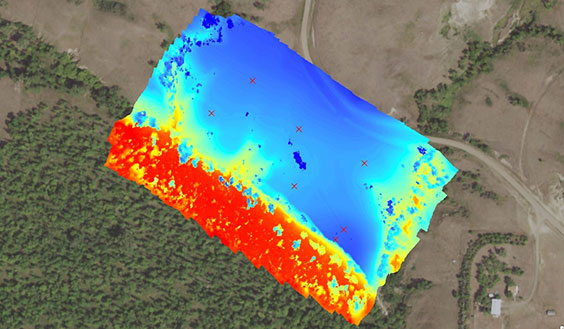
A digital surface model (DSM) of Fort Mandan Overlook. DSMs contain elevation data of the terrain and other features present on the surface (like trees and structures). In this image, the red, orange, and yellow colors represent lower elevations at the site, so the bluff edge at the site can clearly be identified.
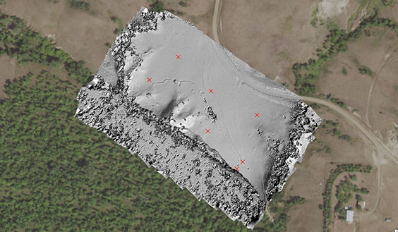
Image showing a relief map of Fort Mandan Overlook. A relief map is a 3-D representation of a surface, with the Sun’s position indicated. Relief maps tend to look realistic and can be useful in interpreting a three-dimensional surface. The fortification ditch and drainages present at the site are clearly visible in this image.
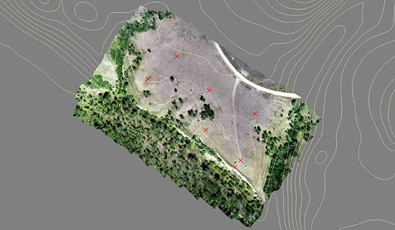
An orthophotograph showing Fort Mandan Overlook. Orthophotographs are aerial images that have been geometrically corrected to minimize distortion so that scale is uniform and features are measurable. Distances and area can be accurately measured using orthophotographs.
State Historical Society archaeologists have “drone mapped” five archaeological sites in this manner so far. While my focus has been primarily on using the drone to document and map archaeological sites, some of my coworkers have begun using similar techniques to model artifacts like stone tools, pottery, and even historic clothing. Keep an eye out for new 3-D projects described in future blog entries!