I would guess that research sounds like a pretty dull job to most people. Nose down in book, hand scribbling notes, eyes growing bleary, back bone slowly coiling into a permanent loop around the desktop. I won’t deny that all of that happens. But the process is also one of discovery. There is always something new, something cool to add the body of knowledge we share with those who read our curricula and newsletters.
When we decided to write about the geology of the Red River Valley for the North Dakota Studies newsletter, I entered the research cautiously. I am a historian. I love documents; I can understand anything old on paper. Layers of dirt are important, but I have always considered rocks and dirt to be someone else’s joy-filled research project. Reading through the documents, I slowly absorbed the geological history of the great glacial Lake Agassiz that formed the Red River Valley thousands of years ago.
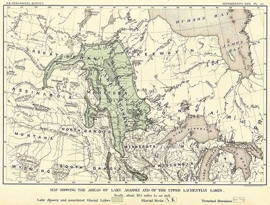
This map of glacial Lake Agassiz was drawn by Warren Upham in 1895. He based it on available knowledge of Lake Agassiz’s shorelines. W. Upham, The Glacial Lake Agassiz
And those numbers! I can easily grasp the historical flow of a couple of centuries, but 11,000 years is almost beyond comprehension. When I read that Lake Agassiz “briefly” overflowed into present day Minnesota for a period of only 300 years, I wondered how many generations of people might have thought of that temporary shoreline as a permanent part of the landscape. You could almost hear their discouraging words as the shoreline where they had always fished receded to the west.
Nevertheless, I learned some very interesting things about Lake Agassiz. The lake did not fill all of the space that is today considered the ancient lake bed. The lake rose and receded, overflowing here and there over several thousand years. Changing water levels left ripples of shorelines that are easily visible in the southern Red River Valley. In forests to the north, the shorelines are more difficult to locate, but new information surfaces from time to time.
Another interesting thing I learned is that the ancient lake is today the focus of research on how global warming might affect North America and the Atlantic Ocean. As the huge lake, the largest in North America, drained through Hudson Bay into the Atlantic Ocean, it changed the chemistry of the ocean and cooled the air temperature of northern hemisphere. At least, that is the current working hypothesis. Climate scientists are still working on the problem, but it appears that the geologic history of Lake Agassiz may help us understand global warming today.
Lake Agassiz’s peculiar geology created the Red River Valley, one of the greatest agricultural regions in the world.
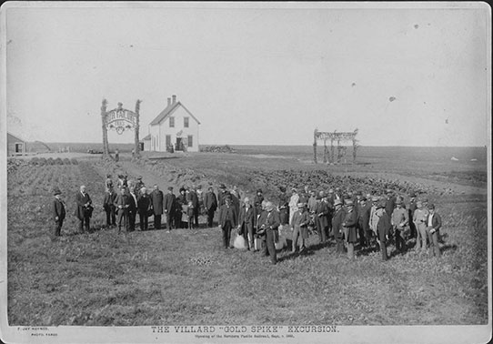
The lakebed of Lake Agassiz formed the large, flat valley of the Red River. In the 1870s, the Red River Valley attracted settlers who found the rich soil was perfect for wheat farming. SHSND C0868
Today, we talk about the land that our grandfathers farmed and about our attachment to this place. I wonder how many more generations will call it home before geological change takes place once again and leaves us wondering where it all went.